Mean Annual Near-Surface Air Temperature
Mean Diurnal Near-Surface Air Temperature Range
Isothermality
Temperature Seasonality
Mean Daily Maximum Near-Surface Air Temperature of the Warmest Month
Mean Daily Minimum Near-Surface Air Temperature of the Coldest Month
Annual Daily Mean Near-Surface Air Temperature Range
Mean Daily Near-Surface Air Temperature of the Wettest Quarter
Mean Daily Near-Surface Air Temperature of the Driest Quarter
Mean Daily Mean Near-Surface Air Temperature of the Warmest Quarter
Mean Daily Mean Near-Surface Air Temperature of the Quarter
Annual Precipitation
Precipitation of the Wettest Month
Precipitation of the Driest Month
Precipitation Seasonality
Mean Monthly Precipitation of the Wettest Quarter
Mean Monthly Precipitation of the Driest Quarter
Mean Monthly Precipitation of the Warmest Quarter
Mean Monthly Precipitation of the Coldest Quarter
Total Cloud Cover Percentage
Monthly Climate Moisture Index
Frost Change Frequency
First Day of the Growing Season TREELIM
Growing Degree Days Heat Sum above 0 °C
Growing Degree Days Heat Sum above 10 °C
Growing Degree Days Heat Sum above 5 °C
First Growing Degree Day above 10 °C
First Growing Degree Day above 5 °C
Ice Sheet Surface Altitude
Growing Season Length
Accumulated Precipiation Amount on Growing Season Days
Mean Temperature of Growing Season Days
Near-Surface Relative Humidity
Köppen-Geiger Climate Classification
Köppen-Geiger Climate Classification
Köppen-Geiger Climate Classification
Köppen-Geiger Climate Classification
Köppen-Geiger Climate Classification
Köppen-Geiger Climate Classification
Last Day of the Growing Season TREELIM
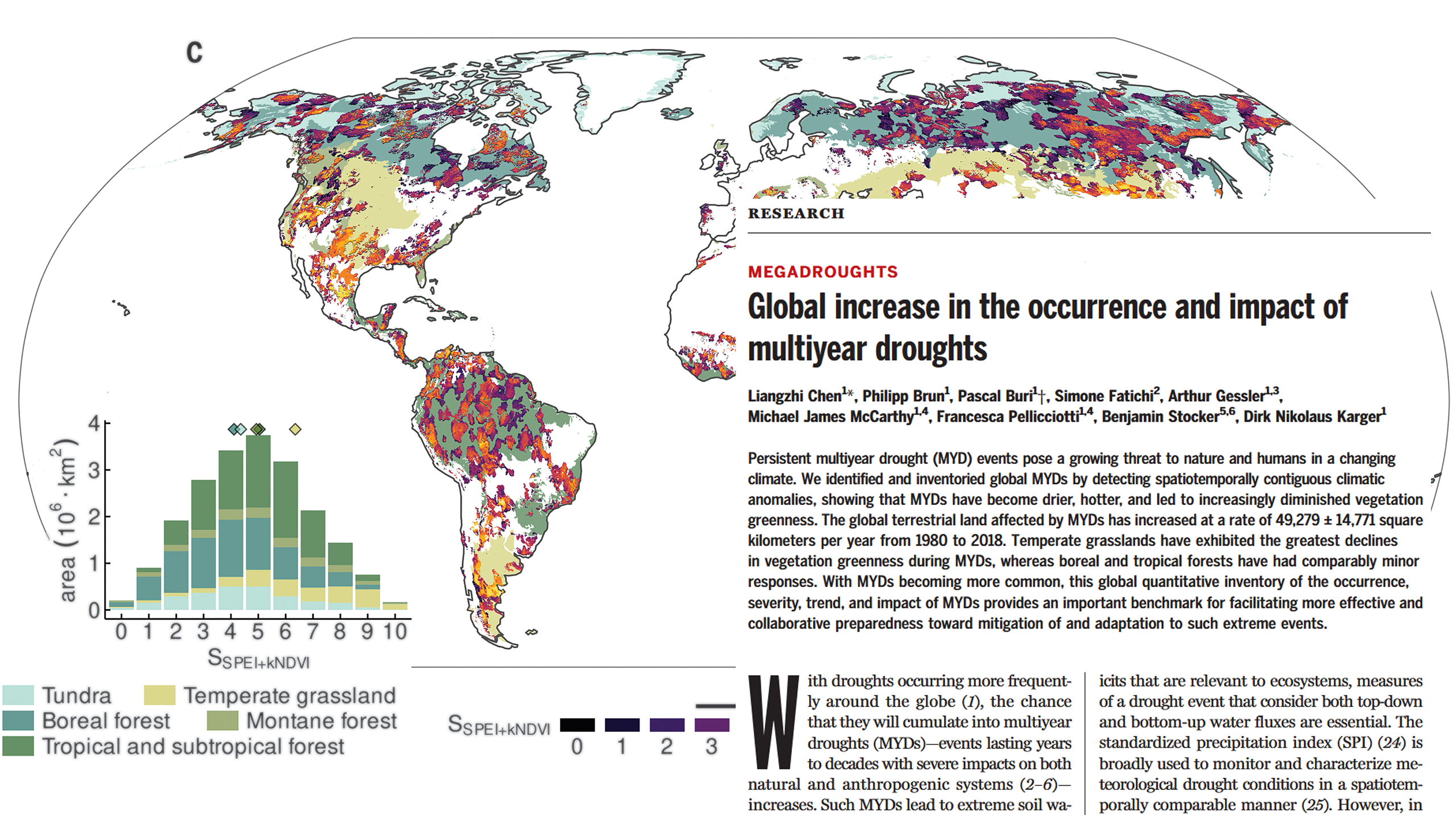
Multiyear Meteorological Drought
Multiyear Meteorological Drought
Number of Growing Degree Days above 0 °C
Number of Growing Degree Days above 10 °C
Number of Growing Degree Days above 5 °C
Net Primary Production on Land as Carbon Mass Flux
Surface Altitude
Monthly Potential Evapotranspiration
Precipitation
Surface Air Pressure
Kernel Normalized Difference Vegetation Index Anomaly
Surface Downwelling Shortwave Flux in Air
Snow Cover days
Near-Surface Wind Speed
spei
spi
Snow Water Equivalent
Daily Mean Near-Surface Air Temperature
Daily Maximum Near-Surface Air Temperature
Daily Minimum Near-Surface Air Temperature
Air Temperature Lapse Rate
Vapor Pressure Deficit