Model overview: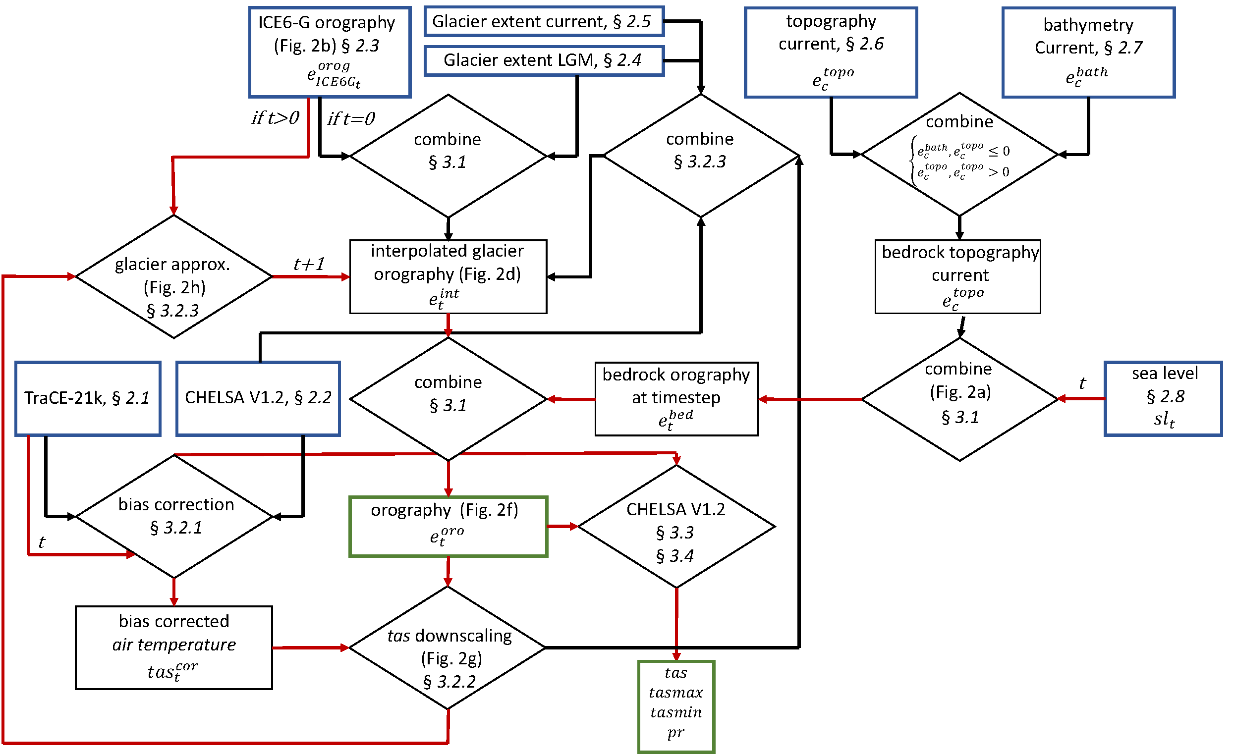
Figure 1 | Graphical representation of the different steps employed in downscaling TraCE-21k simulations using the CHELSA V1.2 algorithm from (https://doi.org/10.5194/cp-19-439-2023). Input datasets are indicated by a blue box; output data are indicated by a green box. Rhombi indicate processing steps; t indicates discrete time steps, with t=0 being the LGM. Red lines indicate processing steps that are run iteratively over all time steps; black lines indicate computations that were run only once.
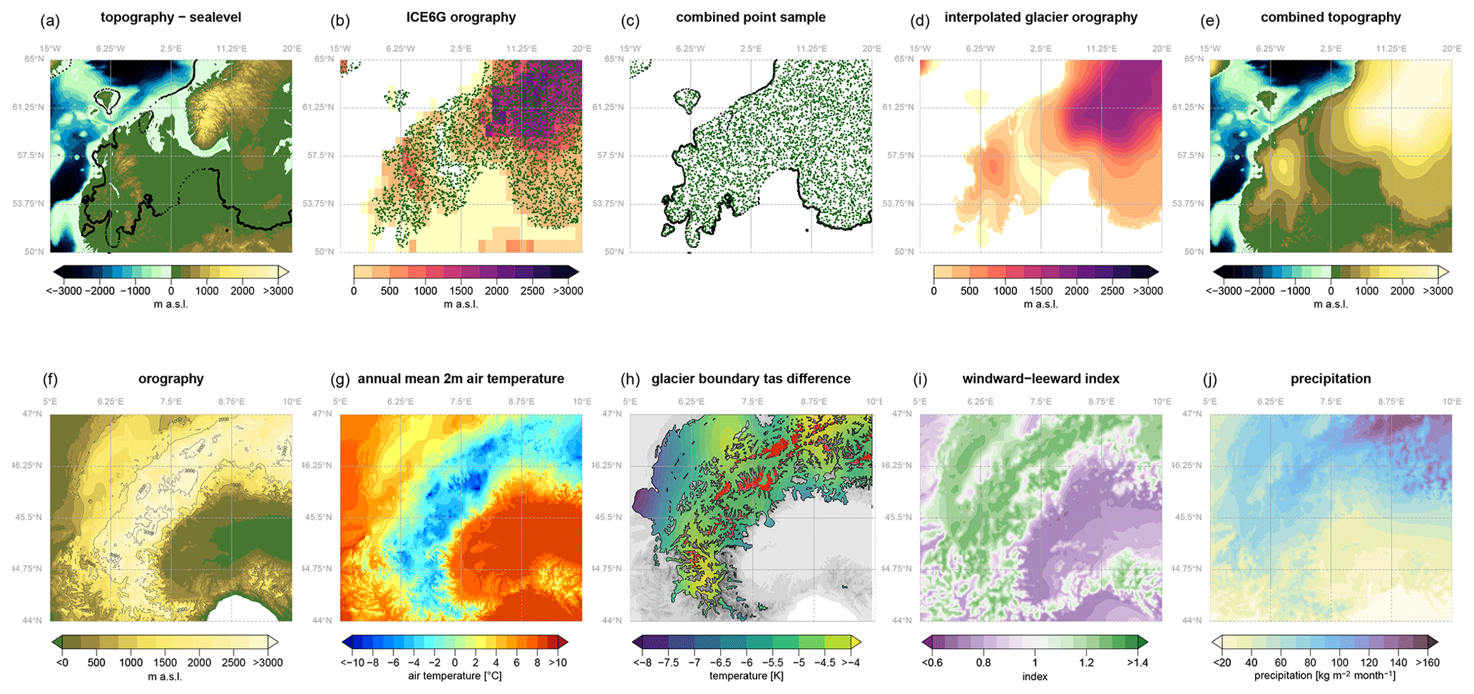
Figure 2 | Illustration of several steps performed to estimate the surface orography and the temperature and precipitation fields in CHELSA-TraCE21k during the Last Glacial Maximum (21 ka) from (https://doi.org/10.5194/cp-19-439-2023). The upper row gives an example of the interpolation of the European ice sheets; the lower row shows an example of the resulting orography and environmental variables in the western part of the European Alps. (a) Topographic information at t=0 (LGM) is combined with information on past sea levels and the boundary of ice sheets (black dots) for which the surface elevation is extracted. (b) Within the extent of ice sheets, surface elevation is extracted from the ICE6G orography for a random sample of points for t=0. (c) Both point samples from (a) and (b) are combined and interpolated (d) to estimate the orography of the glaciers. (e) The interpolated glacier orography and the sea-level-adjusted topography are then combined. (f) The high-resolution (30?arcsec) orography (shown here for the western Alps) is then used as a basis at t=0 for (g) a lapse-rate-based downscaling of air temperature. (h) From the high-resolution temperatures, information on the glacier boundaries during the LGM (black) and current times (red) is extracted, and the difference is interpolated to correct the temperature-based shrinking and expansion of the glaciers. (i) Based on the orography the windward–leeward index is calculated (shown for July 21?ka), which builds the basis for the (j) precipitation approximation.
Input Data:
CHELSA-TraCE21k downscales monthly gridded climate fields from the TraCE-21k Earth system model simulation, which provides coarse-resolution paleo-atmospheric variables over the last 21,000 years. Input variables include monthly mean 2?m air temperature (ta), surface-level minimum and maximum air temperatures (tasmin, tasmax), wind components at surface and pressure levels (uas, vas), geopotential height (zg), and orographpy (orog). These inputs are used to calculate temperature lapse rates, windward–leeward exposure, planetary boundary layer corrections, and orographic shadowing. Orography is reconstructed dynamically for each time step using high-resolution elevation models, glacier reconstructions from LGM and present, sea level change data, and ice sheet thicknesses from ICE-6G_C. The downscaling produces monthly high-resolution (30?arcsec) outputs of near-surface air temperature (tas), minimum air temperature (tasmin), maximum air temperature (tasmax), and precipitation (pr) for each 100-year time step. These outputs are physically informed by topography, atmospheric structure, and glacier-driven terrain changes across time, enabling consistent high-resolution reconstructions of paleoclimate from the Last Glacial Maximum to the present.
Downscaling Methodology:
The downscaling approach in CHELSA-TraCE21k is a terrain-based, physically driven method adapted for paleoclimate conditions. It converts coarse-resolution paleo-atmospheric outputs from the TraCE-21k simulation into high-resolution climate data by incorporating topographic complexity and time-evolving surface conditions. The method uses dynamically reconstructed orography, which includes elevation changes due to glaciers, sea level shifts, and ice sheet thicknesses. Climate variables are downscaled through temperature lapse rate corrections, windward-leeward differentiation, orographic shadowing, and planetary boundary layer adjustments. The procedure simulates how historical terrain and atmospheric conditions influenced local climates by applying physically based algorithms consistent with the CHELSA V.1.2 model.
Bias correction:
For air temperature, a change factor bias correction is implemented using the difference between simulated annual-mean 2 m temperatures from TraCE-21k and observed temperatures from CHELSA V1.2 for the overlapping period 1980–1990. This bias is computed at 0.5° resolution and spatially interpolated using a multilevel B-spline method. The correction is then applied uniformly across the entire time series under the assumption that the model bias remains constant through time. This approach preserves long-term trends in simulated temperatures while adjusting for systematic biases in the GCM outputs.
Validation summary:
The validation of CHELSA-TraCE21k addresses the challenges of assessing high-resolution paleoclimate data by combining modern observational comparisons with proxy-based assessments and derived parameter validation. Direct validation of the downscaled temperature (tasmin, tasmax) and precipitation (pr) fields for paleo time steps is limited by the absence of direct observations. Therefore, validation relied on three complementary approaches: Comparison with Historical Observations: For the modern period (1950–1990), CHELSA-TraCE21k was validated against monthly station data from the GHCN V3. The downscaling significantly improved agreement with observations compared to the coarse-resolution TraCE-21k simulation. Correlations for temperature increased from r 0.8 to r 0.95, while precipitation correlations improved from r 0.4 to r 0.7. Standard deviation and RMSE were reduced for all variables, especially in topographically complex regions. Proxy-Based Evaluation: Temperature time series from CHELSA-TraCE21k were compared with ice core reconstructions from eight Greenland sites. The downscaling reduced biases at edge sites (e.g., ReCAP, Agassiz), though central sites showed mixed performance. Both TraCE-21k and CHELSA-TraCE21k showed warm or cold biases at different time intervals, reflecting model and proxy uncertainties. Nevertheless, CHELSA-TraCE21k often yielded a better match to the long-term trends and variability in the reconstructions. Glacial Extent Validation: To assess model realism across the full 21,000-year time span, CHELSA-TraCE21k-derived glacier extent was compared with mapped reconstructions from North America and Fennoscandia. Results showed strong agreement across most time steps, particularly before 10 ka, with validation metrics (balanced accuracy, Cohen’s kappa, TSS) supporting high spatial coherence. A notable drop in accuracy around 8 ka likely reflects known paleoclimate events (e.g., 8.2 ka cooling) and their complex interactions with glacier dynamics. Together, these validation approaches highlight the improved spatial detail, reduced systematic biases, and greater consistency of CHELSA-TraCE21k over both raw TraCE-21k outputs and traditional paleoclimate products—especially in regions with strong topographic control over climate.
Variable specific downscaling algorithms:
| variable | Downscaling |
| pr | Precipitation is downscaled by simulating key orographic processes: Wind Effect: The model calculates a wind exposure index for each grid cell using wind components. Terrain is scanned in the wind direction to assess whether a location is windward (more exposed, more rain) or leeward (sheltered, less rain). This is done using a directional terrain scan based on slope and relative elevation. Boundary Layer Correction: Terrain influence is strongest where the surface intersects the planetary boundary layer (pbl), the lowest part of the atmosphere where most weather occurs. CHELSA-TraCE21k uses the lifted condensation level to adjust the wind effect based on how much the terrain penetrates this layer, reducing unrealistic orographic influence where terrain is either too low or too high. Valley Exposition: High mountain valleys can be rain-shadowed even when nearby peaks receive substantial precipitation. CHELSA-TraCE21k. includes a valley exposition index that simulates how deeply embedded a valley is and reduces precipitation accordingly. These mechanisms are used to redistribute the total precipitation within each coarse grid cell, scaling the values to match the original coarse grid totals while resolving realistic local variability. |
| tasmax, tasmin | Temperature is downscaled based on the relationship between elevation and atmospheric temperature. In general, air cools with increasing altitude — a pattern described by the lapse rate. The model first interpolates coarse temperature fields to a finer grid and then adjusts these values according to the local topography. Where terrain is higher than the surrounding area, temperatures are reduced; where it is lower, they are increased. This lapse rate adjustment captures fine-scale variations in temperature caused by mountains, valleys, and slopes. The same principle is applied to daily mean, maximum, and minimum temperatures. While this method works well in most landscapes, it can be less accurate in conditions like nighttime cold-air pooling, where local temperature patterns deviate from the general lapse rate. Still, it substantially improves temperature representation in complex terrain compared to uncorrected coarse-resolution data. |
| orog | Orography in CHELSA-TraCE21k is dynamically reconstructed for each time step by combining glacier elevation (glz) with a high-resolution digital elevation model (DEM) corrected for global sea level change. For land areas, the base terrain elevation is taken from GMTED2010, as used in CHELSA V1.2, to ensure consistency across time steps. For ocean basins, the General Bathymetric Chart of the Oceans (GEBCO 2014) is used to provide bathymetric data. To account for temporal changes in topography driven by glacial cycles, the orographic surface is adjusted for global sea level changes using the proxy-based reconstruction These sea level estimates, derived primarily from tropical reef data, capture fluctuations from the Last Glacial Maximum (LGM) to the present. At each time step, the adjusted land and ocean elevations are merged with the modeled glacier elevation (glz) to produce a continuous, high-resolution orographic field. This time-evolving orography (orog) is essential for simulating climate-topography interactions, such as temperature lapse rates, wind exposure, and precipitation redistribution, and ensures a physically coherent paleoclimate reconstruction across 21,000 years. |
| gle | Glacier extent is approximated using a temperature-threshold method that links mean annual 2 m air temperature to glacier boundaries. At the Last Glacial Maximum (LGM, t=0), high-resolution glacier outlines are extracted and transformed into polygons. Points sampled along these boundaries provide the annual-mean air temperature under which glaciers existed during this period. These boundary temperatures are compared to modern glacier boundary temperatures (t=221, or 1990) to calculate a spatial temperature offset. This offset is interpolated into a continuous surface using multilevel B-spline interpolation. At each time step, the interpolated threshold is applied to the modeled temperature field to estimate glacier extent. The glacier extent is updated iteratively, and temperature thresholds are gradually adjusted over time to avoid abrupt shifts in glaciation. This approach ensures consistent tracking of glacial retreat or advance in response to changing climatic conditions. |
| glz | Glacier elevation is computed based on the derived glacier extent and associated orography. For each time step, glacier elevation is determined by combining the estimated extent with terrain elevation data. When available, ICE6G reconstructions of major ice sheets are used to define glacier surface elevation. In areas not covered by ICE6G (e.g., smaller alpine glaciers), current glacier boundary elevations are sampled and interpolated to estimate surface height. A multilevel B-spline method is used to create a continuous glacier elevation surface. This glacier topography (glz) feeds back into the climate downscaling process, updating orographic influences such as lapse rate corrections and wind exposure for subsequent time steps. The elevation is recalculated iteratively, maintaining consistency between glacial geometry and the underlying terrain and climate variables. |